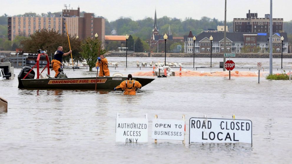
Crews evacuated people from some buildings and cars Tuesday afternoon after a flood barrier failed along the Mississippi River, sending floodwaters rushing into downtown Davenport, Iowa.
The National Weather Service sent an alert around 4 p.m. of a flash flood emergency in Davenport, urging people downtown to immediately seek higher ground. Public works officials reported that a temporary flood barrier had failed and that many people sought shelter on the rooftops of downtown buildings.
“It was just the one barrier, so we’re not expecting the flooding to spread beyond what we’re seeing now,” Davenport Public Works Director Nicole Gleason said. “That could change with heavy rain.”
Gleason said crews and volunteers scrambled Tuesday afternoon to fill sandbags for other downtown businesses looking to keep the floodwaters out of their buildings.
The breach hit as communities in Iowa, Illinois and Missouri prepare for record or near-record crests along the river. The National Weather Service already issued flood warnings for areas directly on either side of the river in 10 states, “all the way to the Gulf of Mexico,” said meteorologist Mike McClure in Davenport.
The floodwaters had overtaken vehicles and the first floors of some buildings on the river’s edge, and rescue crews could be seen launching boats into the floodwaters to retrieve people stranded by the sudden surge.
Mayor Frank Klipsch said there were no reports of injuries. He asked that people stay away from downtown while officials work to evacuate the area.
“This is a couple blocks of one part of our city. It’s fortunately a relatively small area being flooded,” Klipsch said.
In Iowa, some cities on the river’s banks — including Davenport and Muscatine — had already closed some low-lying streets and erected flood walls and sandbag barriers.
Flood watches have been issued for larger tracts around in the river in Iowa, Illinois and Missouri, as well as sections of Kansas, Oklahoma and Arkansas, as heavy rain that began in some places Monday was set to continue into Wednesday.
The rain comes as the Mississippi River is set to reach record or near-record crests in Iowa, Illinois and northern Missouri.
In suburban St. Louis, the river is expected to reach 9 to 10 feet (2.74 to 3.05 meters) above flood stage Saturday at several locations in northeast Missouri and at Quincy, Illinois. With up to 4 inches of rain possible in the region through Friday, the weather service cites a high risk of flash flooding and warns that river forecasts could rise even higher.
If the river reaches the projected 24.2 feet in Louisiana, a town of 3,300 residents some 90 miles (144.83 kilometers) north of St. Louis, roads and highways will be covered, railroad tracks will be swamped, and the Champ Clark Bridge crossing the river will have to close, Pike County, Missouri, Emergency Management Director Al Murry said.
Water that high also could threaten levees that protect thousands of acres of farmland.
“The potential for cropland damage if you have a levee burst — that’s a really big deal,” Murry said.
At 5 p.m., the Mississippi River at Davenport was recorded at 21.88 feet — the fifth highest for the spot ever recorded, according the National Weather Service. That’s approaching the record crest of 22.6 feet (6.9 meters) set in July 1993.
The river’s expected to crest Wednesday evening a few inches short of the record.
The gauge in nearby Muscatine showed the river just under 3 feet (1 meter) below the July 1993 record of 25.6 feet (7.8 meters). It’s expected to crest a little more than a foot under the record at Muscatine, where officials have placed new berms and are diverting downtown traffic.
———
Associated Press writer Jim Salter in St. Louis contributed to this report.


